From the Merthyr Express 100 years ago today…..

The Melting Pot – Merthyr Tydfil's History and Culture
In Association with the Merthyr Tydfil & District Historical Society

From the Merthyr Express 100 years ago today…..
I hope everyone is continuing to enjoy reading this blog.
 It does cost quite a bit to keep the blog up and running (for internet fees, the site domain etc.), so if anyone would like to make a donation to help keep the blog going, any contribution, no matter how small would be greatly appreciated, and every penny will go towards the cost of running the blog. I am very grateful to everyone who has already given a donation.
If you would like to contribute something, please see the Paypal application in the side-bar to the right. It will certainly help to keep this blog going.
Please don’t feel that you have to donate – you certainly don’t, I just want people to enjoy reading this blog as much as I enjoy compiling it, but if you would like to contribute – thank you very much.

GEORGE STREET, GEORGETOWN


Everything about this area has changed!!! The Dynevor Arms has gone, all of the houses on George Street have gone – even the famous Hill House, home to the Williams family for many generations (which can be seen at the top of George Street in the first photo), the roundabout is in a different place, and even the tips are no more!!!
Strangely enough, the cars have changed too!!!!
Redevelopment – an improvement or just wanton vandalism? What do you think?
We continue our serialisation of the memories of Merthyr in the 1830’s by an un-named correspondent to the Merthyr Express, courtesy of Michael Donovan.

The first thing met would be another turnpike, then a few cottages; one was a public-house, next to which a space or front yard of the Plymouth Arms. On the right hand side for some distance a wall was the only thing between Bridge Street and the River Taff, but the weir not far down diverted its water into the feeder as it was called. The continuation of the river wall kept the road safe for traffic, until further down, after passing the Isle of Wight and the entrance to Caedraw at the end of Swan Street there really was not any protection. However, even that had some advantage, for a leading tradesman, in his evidence as to the sanitation of Merthyr, recommended the use of buckets and their discharge into the watercourse! Brilliant idea!
From the Plymouth Arms dwellings adjoined each other. One was the Duke of York Inn, whose money-box was ransacked in the lodge-room once, and the thief never detected.

A little lower was the Greyhound. The son of the person who had kept this was Mr Edward Lewis Richards, a barrister, who through its becoming known that he was a partner in a brewery there, did not receive the appointment he had hoped for, viz, the stipendiaryship of Merthyr; but got that of Judge of a North Wales County Court, and died at Mold many years ago. A Mrs Todd kept a grocer’s shop a little further on, and then small cottages continued awhile. The rectory was not built.
The end of Albert Street was only an entrance into the field now covered with buildings, and The Hollies was Mr Meyrick, the solicitor’s office. He resided at Gwaelodygarth, which was his own property.
After the death or removal of the Rev Mr Jones a Rev Thomas Williams officiated in the old church, and he resided between Swan and Salmon Streets on the left. It was an old house; it stood by itself, with its gable abutting the road alongside the feeder.
There were three or four bridges over the watercourse. The first was to the house and shop of the Williamses “over the pond” as they were known by. Old Mr Williams had been a veterinary man. His son kept an ironmonger’s shop there. One daughter became a Mrs Davies, another a Mrs David James, and another a Mrs Petherick. Another bridge lower down was to the slaughter-house and the Crawshay’s Arms adjoining; a third, at the end of Three Salmons Street led into Caedraw, and a fourth to the public house adjoining the road.
Just below were the ruins of the old grist mill, which formed an important factor in a lawsuit at one time, but which will be told with other things connected with it by-and-by.
We are now again at the end of Mill Street, with the stocks at its other end, and have completed a peregrination right around the chief part of “the village” as it then existed. Only the short roads have yet to be traversed, the one Quarry Row, and the other the Grawen, or Brecon Road, and after that we will go through Penydarren to Dowlais.
To be continued at a later date…….
25 years ago today….


by Gwilym and John Griffiths
Cwm Cannaid Tramroad: We do not know when this tramroad was constructed. We would guess it was sometime around 1800-1814. Despite its name, the tramroad was built before the shaft of Cwm Cannaid Colliery was sunk. The track was shown clearly on the 1814 Ordnance Survey Map and on Robert Dawson’s 1832 Boundary Commission Map whereas the shafts of Cwm Cannaid Colliery were apparently sunk about 1845. The purpose of the tramroad was to relieve the inefficient old tub canal, or coal canal, sometimes called the Cyfarthfa Coal Canal, of the 1770s. The latter transported coal (and perhaps ironstone?) in two-ton tubs from levels (some suggested via dangerous leats) in Cwm Cannaid to Cyfarthfa Works: some say horse-drawn, others say hauled or pushed by men and women. The Cyfarthfa Coal Canal was closed around 1835, which gives an explanation of Cwm Cannaid Tramroad on Robert Dawson’s 1832 Boundary Commission Map.
The tramroad followed roughly the route of the old coal canal: the latter a twisting route, the former almost a straight line. It skirted Glyn Dyrys Ironstone Mine, a coal shaft below Lower Colliers Row, in front of Lower Colliers Row itself, Tir Wern Uchaf (where it crossed the canal twice), a link to Cwm y Glo Colliery and Ironstone Mine, Upper Colliers Row, Tir Heol Gerrig and hence to the coke ovens and yards above (to the west) of Cyfarthfa Works.

When Cwm Cannaid Pit was sunk in 1845, that became the terminus of the system. The 1901 Ordnance Survey Map named it ‘Cwm Pit Railway’, and the line linking it to ‘Gethin Railway’ was labelled ‘railway in course of construction’. We saw the remnants of these mines, canal and tramroad in the 1940s and 1950s, and often walked the old canal embankment, by then well wooded.

Again, industrial despoliation was reverting to nature: delicious wild strawberries on the old waste tipping, a nightingale singing by the disused and reed-covered canal reservoir, woodcock and common snipe, pied flycatchers and wood warblers, and numerous other birds; with wild orchids amongst the damp marshy vegetation with dragon-flies, damsel-flies, glow-worms and water-boatmen. We doubt if this still exists in the coniferous plantations which replaced them all in more recent years.
Dowlais Tramroad: This was constructed about 1792-93 to connect Dowlais Works with Pont y Storehouse near the Glamorgan Canal terminus, roughly near present-day Jackson’s Bridge. It gave Dowlais Works access to the then ‘recently’ constructed Glamorgan Canal. The route may well have followed initially the Morlais Quarry Tramroad from Dowlais via Gelli Faelog, keeping to the Gelli Faelog side of Nant Morlais. The 1793 extension from this tramroad is today represented by the main road and high pavement from Trevithick Street down to Pont Morlais and thence via the tunnel, formerly a bridge, into Bethesda Street to Jackson’s Bridge. Did the Glamorgan Canal Company pay the £1,100 for the construction of the tramroad (and Jackson’s Bridge) in lieu of the proposed linking canal from Merthyr Tudful to Dowlais?

Gethin Tramroad: This tramroad or railway linked Gethin Colliery (sunk between 1845 and 1849 and opened 1849) initially, and Castle Colliery later (1860s?), with Cyfarthfa Works, taking a route in between those of Cwm Cannaid Tramroad and Ynys Fach Tramroad. No tramroad was shown on the 1850 Tithe Map and Schedule. By 1886 the track left Castle Colliery, skirted the hillside west of the Glamorgan Canal between Furnace Row and Tir Pen Rhiw’r Onnen, through Gethin Colliery (with a link to pit-shaft No2), past Graig Cottage and a bridge over Nant Cannaid. At (the 1853) Cyfarthfa Crossing it curved northwestwards past Tir Wern Isaf and Tir Llwyn Celyn, looping under the 1868 Brecon and Merthyr Railway near Heol Gerrig, and thence to the coke yards.

By 1886 the route was upgraded to the GWR and Rhymney Railway as far as the Cyfarthfa Crossing. The 1876 six-inch Ordnance Survey Map showed the terminus for the ‘cwbs’ at the rear of Cyfarthfa Works. The 1901 Ordnance Survey Map called it ‘Gethin Railway’. Our grandfather used the railway to get to work at Castle Colliery, and we regularly used this route (then upgraded to a full railway) in the 1940s and 1950s on our daily journeys to and from school at Quakers Yard. One of us was on the last train to use this line before the viaduct between Quakers yard and Pont y Gwaith was found to be unsafe.
Gyrnos Quarry Tramroad: This was used to bring limestone from Gyrnos Quarry (Graig y Gyrnos) alongside Tâf Fechan, past the limekilns and coal yards, over Afon Tâf by Pont Cafnau to Cyfarthfa Works. We have no details of dates, but walked the route many times in the 1950s in search of dippers, kingfishers, grey wagtails and the rest. It was the first tramroad recorded in the 1805 list of John Jones and William Llywelyn: 1 mile 106 yards to Cyfarthfa Furnaces and just over 1¾ miles to the new Ynys Fach Furnaces. In view of the size of the quarry, it must have transported many tons of material.

by Gwilym and John Griffiths
TRAMROAD: According to the Oxford Concise English Dictionary, ‘tramroad’ is now an historical word: a road with wooden, stone or metal wheel-tracks; a ‘tramway’. Strictly speaking, ‘tramroad’ should be written ‘tram-road’ with a hyphen, but the spelling variation ‘tramroad’ has been used commonly in this district. There were many tramroads constructed in this valley in so-called ‘historical’ times, though we can still recall many of them very well indeed and had much fun in our youth having rides on the trams.
Blaen Cannaid Tramroad: This tramroad linked several of the ironstone and coal levels, as well as later mines and collieries, in the hamlet of Gelli Deg to Cyfarthfa Works. The tramroad started at some ironstone levels about 900-1,000 feet above sea-level near Blaen Cannaid, not far from the site of the sixteenth century iron bloomery or small furnace. The route of the tramroad went between Pen y Cae and Pen y Coedcae, crossing the (unnamed?) stream which fed the small reservoir near Lower Colliers Row; and thence over Nant Cwm y Glo to Cwm y Glo Colliery and Ironstone Mine.

Thereafter it continued northwards to Coedcae Ironstone Mine, over Nant Cwm Pant Bach, across the road Heol Gerrig, linking with Cwm Cannaid Tramroad at the coke yards behind the furnaces at Cyfarthfa Works. We often walked the area in the 1940s and 1950s but recall nothing of note: merely grassed-over waste tipping, etc. What a pity?
Clyn Mil Tramroad: This tramroad went from Plymouth Works up the steep Clyn Mil Incline to the east, past Prospect House (where some distant cousins of ours, the Coles, lived in the 1940s) and Tir Clyn Mil Uchaf and its lime kiln (where our great-great grandparents, David and Mary Morgan, lived and died), and then turning south towards Clyn Mil Colliery and Ironstone Mine.

One link from the tramroad deviated further up the mountainside via Coedcae and the Clyn Mil Inclined Plane to several ‘unnamed’ ironstone levels and southwards to waste tipping on Gwern Las land. Another link went to ‘Waun’ Coal Level on Gwern Las property. Another link went to a clay pit on the south side of Clyn Mil Pond and another tramroad linked northwards to ‘New’ Pit (one shaft for coal and another for ironstone) close to Tir Cwm ‘Blacks’ and then on to the brickworks at Tre Beddau.
A very extensive network of lesser roads, some only temporary, covered the higher part of Tir Clyn Mil and Tir Wern Las and these were used either for transporting ironstone or waste tipping. We have no idea as to dates or any other details, but walked all of these routes on numerous occasions, long after the tramroad lines had been removed, in the 1940s and 1950s. It was a barren area then, with industry all gone, but the despoliation was gradually returning to nature again. Here were the homes of redstarts, wood warblers, even wood larks, with skylarks, meadow pipits and cuckoos towards the higher moorland portions. There is surprisingly little information in print about the Plymouth Works as far as we can trace.
To be continued….
by Keith Lewis-Jones
Plaque sited outside the old St Tydfil’s Hospital, CF47 0BL

William Thomas Lewis (1837-1914), later Lord Merthyr, was probably the most powerful figure in Welsh industry in the decades before 1914.
From a lowly beginning in 1855, he rose, by 1880, to be the manager of all of Lord Bute’s mineral, docks, railways, urban and agricultural property. He became a major coal owner and established the Lewis Merthyr Consolidated Collieries Ltd. He was Chairman of the Coalowner’s Association and was totally opposed to trade unions.
He was made a Freeman of the Borough in 1908 and was raised to the peerage in 1911.
Statue & plinth – Grade II Listed

History
Granite plinth dated 1900. Bronze statute by T Brock RA, sculptor of London, 1898.
The monument was relocated from the original site outside the General Hospital.
Description
Standing, bearded figure with arms across front holding unrolled document or plan. Miners’ lamp and pile of papers at rear of feet. Tapering pedestal with moulded cornice and stepped plinth. Bronze heraldic plaque to front.
Long (rear) inscription of good works begins: “Erected by the Voluntary Subscriptions of Friends and Admirers….”.
Listed Building information kindly supplied by CADW ©
Scheduled Ancient Monuments information kindly supplied by The Royal Commission on the Ancient Monuments of Wales – RCAHMW ©
by J Ann Lewis
Ninety-five years ago today, on 4 July 1926, General Marden unveiled the Pant War Memorial, with about 1,300 people in attendance and with loud speakers and microphones were in place for the event. Pant was the second village in the area to erect a memorial to the men killed in the First World War.
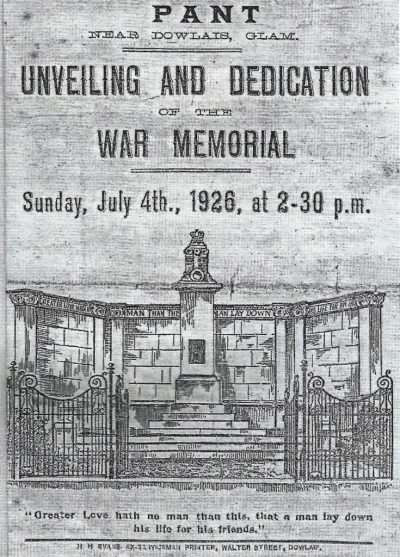
The Memorial Committee was inaugurated in 1920; house-to-house collections were organised and many promises of weekly contributions were made, but due to the coal strike of 1921, and the trade depression that followed, the final cost of £800 was not quite met. The local inhabitants had paid the bulk of the money, and the school-children contributed largely through the many concerts organised by the staff. Also mentioned for their donations were: Merthyr Football Club, the directors of the Victoria Cinema and the Oddfellows Hall (where the concerts were held).
Mr F. J. Bateson released the ground he had rented from Messrs Guest, Keen and Nettlefold, enabling them to give the ground, previously owned by Daniel Thomas, stonemason, for the memorial. Before the memorial could be erected, the urinal built in 1906 had to be moved to the other side of Caeracca Bridge.
The Memorial is built mainly of Portland stone, with the side wing walls and steps leading to the cenotaph of local limestone. The bronze plate centrepiece reveals the names of local men who were killed during the conflict.

Designed by Mr C. H. C. Holder, a curator at Cyfarthfa Museum, the sculpture is a monument to the skill of Councillor F. J. Bateson from Pant and his assistants. The Mayor, Alderman D. Davies J. P., another Pant resident, accepted the deed as a gift from Mr S. J. Lloyd, Secretary of the Memorial Committee. The mayor had actually lost his son in the War, and his name is commemorated on the plaque.
General Marden, in his response, thanked the Dowlais Male Voice Party for “the most wonderful singing he had ever heard”. The march to Pant was led by the Municipal Band and the G.K.N. Dowlais Silver Band.
A second plaque was added to the memorial to honour the men of the village who died during the Second World War.

To the left hand side of the main memorial is another plaque honouring the men who had been employed at the I.C.I. Factory at Dowlais who died in the Second World War. These were: